Ootacamund 
(officially,
Udagamandalam Tamil:
உதகமண்டலம் sometimes abbreviated to
Udhagai Tamil: உதகor
Ooty is a town, a municiplaity and the district capital of the Nilgiri District in the Indian Stateof Tamil Nadu.
Ootacamund is a popular hill station located in the Nilgiri Hills. Originally occupied by the Todas, the area came under the rule of the East India Company at the end of the 18th century. Today the town's economy is based on tourism and agriculture, with manufacturing of medicines and photographic film also present.
The town is connected to the rest of India by road and rail, and its historic sites and natural beauty attract tourists.
View of Nilgiri Passenger Train

Transport infrastructure
Road
Ooty is well connected by good roads. It is 535 km from Chennai (via Salem,Erode), 105 km from Coimbatore, 18 km from Coonoor, 155 km from Mysore (via Gudalur), 187 km from Calicut, 290 km from Bangalore, 281 km from Kochi (via Coimbatore and Palakkad), 236 km from Kodaikanal (via Coimbatore and Palani). Ooty is situated on National Highway 67. It is connected by road to travelers from the states of
Tamil Nadu,
Kerala and
Karnataka via the five main accepted
Nilgiri Ghat Roads. There is also a road from Mettupalayam(Coimbatore District) to Ooty via
Kotagiri. This road does not pass through
Coonoor.
Ooty, being the district capital, has frequent bus connections from nearby towns in the district such as Coonoor, Kotagiri and
Gudalur. There are bus connections to most villages in the district via one of these three towns. There are also frequent bus connections to the nearby mainline railway stations of
Mettupalayam and
Coimbatore. The town also has direct bus services to various cities and towns of Tamil Nadu, namely
Coimbatore,
Tirupur,
Erode,
Salem,
Sathyamangalam,
Karur,
Dindigul,
Chennai,
Thiruchirapalli,
Madurai,
Thanjavur and
Kanyakumari. There are several bus services to and from the nearby cities of
Mysore and
Kozhikode (in the two bordering states). Direct buses can be boarded for Ooty from many other parts of Karnataka and Kerala, including local connections to
Palghat,
Nilambur and
Sulthan Bathery in Kerala, as well as
Gundlupet in Karnataka. The capital cities of these two states (
Bangalore and
Thiruvananthapuram respectively) as well as
Puducherry(
Pondicherry) are also connected via direct bus links.
Rail

The Nilgiri passenger train (NMR) on the rack section
Air
Ooty does not have a civilian airport and is not connected by air. The nearest airport is
Coimbatore International Airport which has regular (
Air timings) flights from
Delhi,
Kolkata,
Mumbai,
Ahmedabad,
Bangalore,
Calicut,
Chennai,
Cochin,
Hyderabad,
Thiruvananthapuram,
Jammu,
Pune,
New Delhi,
Bangkok,
Kuala Lumpur,
Bahrain,
Kuwait,
Muscat,
Sharjah,
Abu Dhabi,
Colombo,
Dubai,
Doha,
Singapore etc.
Steps are being undertaken to start a helicopter shuttle service from the nearest airport to Ooty for fixed wing aircraft which is in
Coimbatore. It will initially be serviced by a
Bell 407 marketed and run by J.B.Aviation with the aircraft leased from the air service provider
Pawan Hans.
Tourist and historical landmarks

The Government Botanical Garden
Located in the Blue Mountains of the
Western Ghats, Ooty draws a large number of tourists every year. Lofty mountains, great lakes, dense forests, sprawling grasslands, miles of tea gardens and
eucalyptus trees greet the visitors en route to Ooty. The hill station itself is a land of picturesque picnic spots. It used to be popular summer and weekend getaway for the British during the colonial days, later it was made into a summer administrative town. It is situated at an altitude of 2,286 meters above sea level.
Government Rose Garden
The
Government Rose Garden (formerly known as the Centerary Rose Park) is situated in Vijayanagaram of Ooty town, on the slopes of the Elk Hill. Today this garden has the largest collection of roses in the country like Hybrid Tea Roses, miniature rose, Floribunda, Ramblers, roses of unusual colours like black and green are some of the more than 17,000 varieties of roses that are planted in the park. The rose varieties planted in this park were assembled from different sources. The 'Nila Maadam' is located in a spot from where viewers can see the entire rose garden.
Ooty Botanical Gardens
The 22-acre (89,000 m
2)
Ooty Botanical Gardens was laid out in 1847 and is maintained by the
Government of Tamil Nadu. The original purpose of the Botanical Gardens was purely academic: to promote and study the various flora in and around Nilgiris. Now, it is open to the public as a park. The Botanical Garden is lush, green, and well-maintained. A flower show along with an exhibition of rare plant species is held every May. The garden has a 20-million-year-old fossilized tree. One can find a diverse variety of flora, ranging from rare trees (like the cork tree, the paper bark tree, and the monkey puzzle tree), flowering bushes and plants, ferns and orchids. Another major attraction is an Italian-style garden bordering a pool.
Ooty Lake
Ooty Lake is an artificial lake built by John Sullivan. It used to be much larger than its present size of 4 km
2. It is 2.5 km long and encompassed the present bus stand and race course as well as much of the present market. Boating is the major attraction at the lake. The boat ride allows visitors to enjoy the serene environment at a laid-back pace. The lake is bound by groves of eucalyptus trees which augment the scenic beauty of the area. Next to the lake there is a Mini Garden with an amusement park for children.
Stone House
Stone House was the first properly built house in Ooty (at the area called old Ooty), built by John Sullivan. It is inside the premises of the Government Arts College. It now houses government offices.
Toda huts
There are a few
Toda huts on the hills above Botanical Garden, where Todas still dwell. There are other Toda settlements in the area, notably Kandal Mund near Old Ooty.
Ooty Mountain Railway
The railhead of the
Nilgiri Mountain Railway. The station is part of the
World Heritage Site. Ooty Railway station offers a unique glimpse of the British raj built railways. The Nilgiri Mountain Railway is one of the oldest mountain railways in India. Under consideration in 1845, the line was finally opened by the British in 1908 and was initially operated by the Madras Railway Company. The railway is one of the few in the world that is dependent on
steam locomotives.
St. Stephen's Church
St. Stephen's Church is one of the oldest churches in the town and is a local landmark. Its architecture is essentially early Gothic revival with stained glass typical of the era. It differs from British churches of the same time as it has simplifed buttresses and a stucco exterior. The churchyard is full of colonial headstones, and it remains an active place of worship.
Wax World, Ooty
A wax museum that houses life-size look-alike wax statues of personalities of Indian history, culture and heritage housed in a 142-year-old bungalow.
Ooty Golf Links
Tribal Museum
The Tribal Museum is part of the campus of Tribal Research Centre which is in Muthorai Palada (10 km from Ooty town). It is home to rare artifacts and photographs of tribal groups of Tamil Nadu as well as Andaman and Nicobar Islands and anthropological and archaeological primitive human culture and heritage. The Tribal Museum also displays houses belongs to Toda, Kota, Paniya, Kurumba and Kanikaran.
[edit]Tourist spots around Ooty
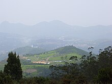
View of Ooty from Doddabetta peak

Tea plantations near Ooty

Pine forest on the way to Pykara falls

Elephant at Mudumalai National Park
Ooty is situated in the
Nilgiri Biosphere Reserve. Many of the forested areas and water bodies are off-limits to most visitors to protect this fragile ecosystem. Some areas of the Biosphere Reserve have been earmarked for tourism development, and steps are being undertaken to open these areas to visitors whilst conserving the area. Much of Ooty has already been damaged by rampant commercialization as a result of tourism. Some of the most prominent tourist spots around Ooty are as follows:
- Doddabetta Peak: It is the highest peak (2,623 m) in the Nilgiris, about 10 km from Ooty. It lies at the junction of the Western and Eastern Ghats and offers beautiful vistas of the Nilgiri Hill ranges. It is surrounded by dense sholas. One can have a panoramic view of the landscape through the TTDC telescope. TTDC restaurant caters the needs of tourists.
- Tea plantations: Tea plantations are at a lower altitude and attract a large number of tourists by their picturesque nature.
- Ketti Valley: This valley is referred to as the 'Switzerland of Southern India' due to the year-round pleasant climatic conditions. There is a view point called Valley View on the main Ooty to Coonoor road. It is also home to CSI College of Engineering, the only engineering college in the district.
- Pykara Lake Boat House and Pykara Falls: This is the most accessible of all the nearby lakes. A boathouse and picnic area has been developed to provide access to this area. Most of the remainder of the lake is within a reserved forest and off-limits to visitors.
- Pine forest: Situated between Ooty and Thalakunda, this tourist destination was once featured in a song sequence in the Tamil movie "Dheena". It is a small downhill region where pine trees are arranged in an orderly fashion.
- Wenlock Downs: This is a grassland area typical of the original bioscape of the Nilgiris. It has gently undulating hills and is often compared with areas in the British isles such as the Yorkshire Dales. This is a popular film shooting area, particularly two areas situated approximately six and nine miles (14 km) out of Ooty on the main Ooty to Pykara road (also known as Mysore Road). These locations are accordingly named "Sixth Mile" and "Ninth Mile".
- Kamraj Sagar Lake: This lake is situated on the way to Pykara lake.
- Mukurthi National Park: A large protected area generally not accessible to visitors. It contains a lake and peak of the same name.
- Needle hill viewpoint is situated between Coodalore and Pykara.
- Parsons Valley Reservoir: This is the primary water source for the town and is mainly in a reserved forest and is thus largely off-limits to visitors.
- Emerald Lake: This lake is near the town of the same name. There is a viewpoint near the dam. The rest of the area is mainly in a reserved forest and is largely off-limits to visitors.
- Avalanche Lake: Adjacent to Emerald Lake, this picturesque lake is mainly situated in a reserved forest and is largely off-limits to visitors
- Porthimund Lake: This is mostly in a reserved forest and is largely off-limits to visitors. Shooting of the blockbuster Tamil movie Roja was done here.
- Upper Bhavani Lake: This lake is in the Mukurthi National Park and largely off-limits to visitors.


 the winter. A natural hotspring is another attraction of the tourist who are said to have had relief of their skin ailment after having bath there. The visit is on the passing of Shingba Rhododendron Sanctuary. Yumthang valley is a mesmerizing scene with yaks grazing on flower - carpeted meadows against a backdrop of towering peaks. It has breathtaking views where one can become a part of a timeless scene without any kind of intrusion. Hot springs, crystal clear streams, water falls, soaring mountains and natures bounty, you name it, you will find it here.


